Upper Bavaria · Bavarian Alps
Herzogstand Hike: Routes, Closure and Safety
The Herzogstand can be a substantial mountain hike, especially while its cable car is closed for valley-station construction. Choose a specific route, allow for the full descent and check mountain weather before setting out. The Heimgarten ridge requires sure-footedness and confidence with exposure. Do not treat a former cable-car itinerary as an unchanged walking plan.
Affiliate disclosure: Some booking links are affiliate links. If you book through them we may earn a commission at no extra cost to you.How we fund this guide
Should you hike the Herzogstand or use the cable car?
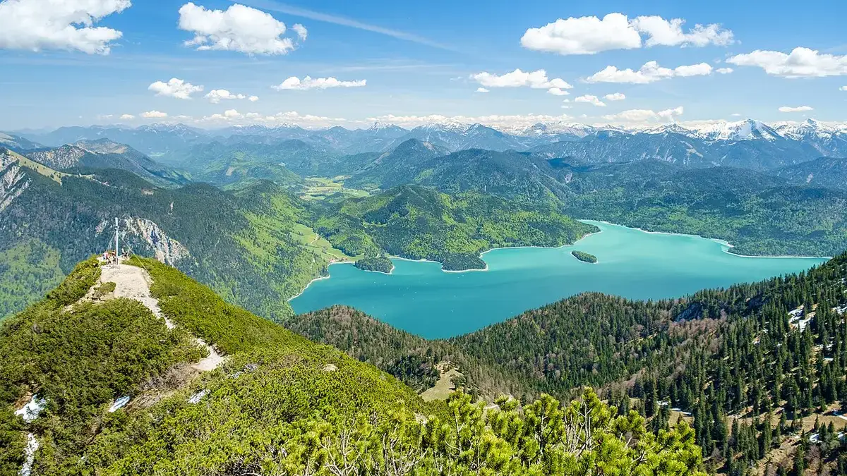
Choose between a mountain walk and a viewpoint visit before planning the journey. These involve different levels of effort. The Herzogstand is a mountain above Lake Walchensee, and a photograph of its summit panorama does not show the work needed to reach it. A cable-car-assisted outing still includes walking, while an ascent from below requires sufficient fitness for both the climb and the return. Start with the broader Lake Walchensee guide if you have not yet chosen a base.
There is an immediate planning issue: checked on 27 October, the operator reports that the Herzogstandbahn is closed from 26 October for construction of the valley station. Reopening is provisionally expected around Pentecost the following year. That is an estimate rather than a guaranteed date. During this closure, do not plan a ride down as your backup if the walk becomes tiring.
What does the closure mean for a hiking day?
Treat any current visit as a walking trip unless the operator has explicitly confirmed resumed service. Old route descriptions may combine a summit walk with a cable-car descent. Their walking totals are therefore not necessarily suitable for the present situation. Check both endpoints and read the return instructions before choosing a route. If the intended return includes the cable car, replace the entire plan rather than simply adding a vague extra hour.
Construction at the valley station also makes it important to check the permitted approach and parking arrangements. A published trailhead does not guarantee unrestricted access through a work area. Follow current signs and do not step around barriers to regain an older GPS track. The official operating-status page should be your first check, followed by the route description and local conditions. Our German cable-car guide provides additional context, with the language clearly indicated by the page itself.
Which walking routes should you compare?
Distinguish a route from the lake, the Reitweg from Kesselberg, and the exposed traverse towards Heimgarten. They are not interchangeable versions of a short summit stroll. A route may have a less technical surface while still being long and physically demanding. Likewise, a short ridge section can require more concentration than several kilometres on a broad track. Match the terrain to experience, not just the distance to available time.
For a first visit, an out-and-back route offers a straightforward decision structure: you return along ground you have already seen. That does not make it automatically easy, but it avoids adding an unfamiliar descent late in the day. A circuit requires enough information about every section, including how the route ends at your original transport. Decide this before leaving the trailhead rather than at the summit.
How long is the Reitweg from Kesselberg?
The operator publishes the Reitweg with a start at Kesselberg pass, a distance of seven kilometres to the Herzogstand summit, 893 metres of ascent and an indicated walking time of three and a half hours. These figures describe the published ascent. They are not a full round trip, and the label easy on that particular listing does not remove the need for mountain fitness or safe conditions.
For your own itinerary, add descent, breaks and the journey to and from the pass. Do not automatically double the stated time and treat the result as a promise: descending speed varies with weather, surface and tiredness. Set a turnaround time that protects the return journey. If you start late, make the destination shorter instead of hoping to recover time on the way down.
Is the Heimgarten ridge suitable for beginners?
The cable-car operator describes the Herzogstand–Heimgarten ridge as requiring sure-footedness, a head for heights and suitable footwear. Its approximate two-hour description concerns the traverse, not the entire mountain day. That distinction matters when reading a photograph-led itinerary. Adding the ridge to an ascent and a descent creates a substantially larger undertaking than walking from an upper station to a nearby viewpoint.
If you are uncertain about exposure, keep the ridge out of your plan. A companion who is comfortable with heights does not make you comfortable with them. Nor does a group moving ahead create an obligation to follow. Turn back before entering terrain that exceeds your confidence. Wet rock, strong wind, snow or poor visibility are reasons to choose a different outing rather than conditions to compensate for with determination.
How should you judge weather and ground conditions?
Check a mountain forecast as well as the forecast for the lakeside village. Conditions at elevation can differ from those beside the water. Consider wind, cloud, precipitation and the time at which conditions are expected to change. A clear morning photograph or webcam image is one piece of information, not a guarantee for the afternoon. Make the decision using the whole day and the intended descent.
If thunderstorms are forecast, do not make an exposed ridge the central element of your plan. If conditions deteriorate unexpectedly, reduce the objective early. Waiting until the summit to reassess can leave fewer sensible options. Poor visibility also changes navigation: familiar-looking paths and other walkers are not a substitute for understanding where your route goes. Carry an offline map and know your chosen return route before you need it.
Can you hike here in autumn and winter?
A summer route description should not be used as a winter instruction sheet. Ice, snow and shorter daylight can alter both difficulty and the time needed. Equipment also requires the knowledge to use it. Buying traction devices does not by itself make a steep or exposed snowy route appropriate. If you lack experience judging winter mountain conditions, choose a lower outing or seek qualified local guidance for the intended day.
Late autumn adds another practical concern: an early finish may be necessary even when the morning feels mild. Check sunset and plan to be off unfamiliar mountain terrain with margin. A headtorch is sensible backup equipment, but it should not become permission to start a long walk too late. During the cable-car closure, the lack of a mechanical descent makes conservative planning especially important.
What should you carry?
Wear footwear suited to the chosen terrain and bring layers that protect against wind and changing temperatures. Carry water, food, a charged phone, an offline map and a way to keep essential items dry. Pack a first-aid kit and a headtorch. Think about whether your group could remain warm if progress slowed, rather than packing only for steady uphill movement. A small reserve is useful when a break lasts longer than planned.
Walking poles may help some hikers, particularly on a long descent, but they do not replace balance or appropriate footwear. Make sure you can safely put them away if hands are needed for the terrain. Keep snacks and water easy to reach so that short pauses remain simple. If you are carrying a child, judge the route for the additional load and for the child’s exposure to cold while sitting still.
What about children and less experienced walkers?
Choose a route around the least experienced person in the group. Distance alone is a poor measure of suitability: elevation gain, terrain, weather and the child’s previous experience all matter. Avoid introducing a first exposed ridge when the group is already tired. A rewarding day does not require the highest point, and turning around before the summit can be the right outcome of a well-managed walk.
Be particularly cautious about describing the current visit as a family cable-car day. The closure removes that straightforward option. Families who mainly want lake scenery may prefer a short lakeside outing instead. Choose a turnaround point with space for a break, and make sure everyone understands that reaching it is optional. Keep the plan flexible enough that nobody needs to continue through discomfort simply to complete a circuit.
Are food and mountain-hut stops guaranteed?
No. Mountain catering has its own operating days and seasonal arrangements. Check the current notices for the Herzogstandhaus and any other intended stop directly before the trip. The cable-car operator currently includes separate information for the mountain restaurant, demonstrating that the railway and catering do not necessarily share identical operating dates. A hut mentioned in an old route description may not be serving when you arrive.
Carry enough food and water for the walk without relying on a purchase. A planned lunch stop can remain a welcome addition, but it should not be essential for completing the route. Also consider the return meal: after a long descent, an evening reservation may be impractical if you still have to reach Kochel and catch a train. Leave room for a slower finish and check kitchen times separately from general restaurant opening hours.
How do you reach the starting point from Munich?
The general public-transport approach is a regional train to Kochel followed by a bus towards the lake. However, the appropriate stop depends on your chosen trailhead. Search the live journey planner using the actual start and finish of the walk. A connection to Walchensee village is not automatically a connection to Kesselberg pass, and a convenient outward journey does not guarantee a useful late return.
Our Munich day-trip guide explains the overall journey and why a single main activity is a sensible plan. For a hiking day, organise the return first and leave a margin for the descent. If driving, confirm current legal parking and trail access rather than assuming the valley-station car park operates normally during construction. Do not stop on a busy road to improvise a trailhead.
Where should you stay for an early start?
An overnight stay can make the start less rushed, but location still matters. Kochel, Urfeld and Walchensee village serve different approaches. Choose accommodation according to the actual trailhead and how you will reach it in the morning. An attractive room elsewhere in the region may add a journey that defeats the purpose of staying overnight. Check breakfast timing and whether an earlier departure is practical.
The hotel guide distinguishes lake-side properties from stays in surrounding towns. Use it to compare bases, then confirm transport and arrival arrangements directly. Do not book a stay solely because a marketing description says it is near the Herzogstand. Near can refer to the wider region rather than walking distance to your intended starting point.
What is the final check before setting out?
Confirm the operating notice, route access, weather, equipment and return journey. Make sure someone outside the group knows your plan and expected return. Keep the route realistic for the slowest participant, and agree on when to turn back. During the walk, reassess at useful decision points rather than waiting for a problem to become urgent. Fatigue, worsening weather and lost time are information that should change the plan.
This guide supports planning; it is not live trail clearance or a substitute for a detailed map. Exact conditions can change after the research date. For an emergency in Germany, call 112 and give your location and the nature of the situation. Use your phone responsibly and preserve battery for navigation and communication. The best day is the one that ends with everyone safely back, whether or not the summit was reached.
Your questions, answered
Is the Herzogstand cable car currently running?
The operator currently reports a closure for construction of the valley station. Check its operating-status page before arranging a visit, as the proposed reopening is provisional. Do not rely on a cable-car descent when planning a walk during the closure. Your route must include a feasible return on foot.
How long is the Reitweg ascent?
The operator publishes seven kilometres, 893 metres of ascent and an indicative three-and-a-half-hour walking time from Kesselberg pass to the summit. These figures describe that ascent rather than the entire day. Add descent, breaks and transport, and choose a turnaround time suitable for your group and the weather.
Is the Heimgarten ridge a beginner walk?
The ridge requires sure-footedness, confidence with heights and suitable footwear according to the operator. It is a different undertaking from a short viewpoint walk. Avoid adding it to a tired group or uncertain weather. If exposure is unfamiliar, choose a route that returns without crossing the ridge.
Can I hike the Herzogstand in winter?
Summer descriptions do not establish winter suitability. Snow, ice, shorter daylight and changing mountain conditions can make the same route a very different undertaking. Appropriate equipment requires relevant experience. If you cannot judge the conditions, choose a lower alternative or obtain qualified local guidance for your particular route and day.
Can I combine the hike with a day trip from Munich?
It may be possible with an appropriate route and transport, but the full walking return must fit the day. Check your last practical connection before departure and allow a generous descent margin. A longer mountain route should be the main activity rather than an addition to a complete lakeside itinerary.